![]()
Satellite Tracking: Physics 2 Research Project by Daniel Ehmig and Sinh Tri (Last Updated on May 16, 2011)
Introduction | Background | Hypothesis | Method | Diagram of Experiment | Data and Calculations | Graphs of Results
Conclusion | Bibliography | Links | GO UP
Research Project Introduction Top
Little is known about the process of satellite tracking. Few people are aware of its existence and even fewer actually participate in the hobby. Despite this, small bands of people who call themselves satellite trackers, observers, or watchers spend much of their time looking up into the sky at the right time and at the right place, hoping to catch a glimpse of the mysterious objects that fly above our heads. With over 3,000 active satellites in orbit today and around 6,000 inactive objects, the satellite trackers have good reason to track these objects (Oberright 2004). However, with ever-evolving technology and the constant occurrence of failures and collisions, most satellite launches are not successful; therefore, most objects an observer will track will be inactive. Observing satellites often consists of no more than knowing where and when to look and using your very own two eyes.
To understand why people track satellites and what the scientific purpose of it, one needs to know what a satellite is and what they are used for. To explain, an artificial satellite is an object that continually orbits the Earth or some other celestial body. The most common uses for artificial satellites are to study the universe, help forecast the weather, transfer telephone calls over the oceans, assist in the navigation of ships and aircraft, monitor crops and other resources, and support military activities (Oberright 2004). Furthermore, any man made object that orbits the Earth can be considered an artificial satellite. For example, manned spacecraft in orbit, space “junk” such as burned out rocket boosters and empty fuel tanks, and the scientific and military objects that are placed in the sky are all considered artificial satellites. In addition, the various types of orbits, the velocities of the satellites, and the altitudes by which they travel all are important in the process of satellite tracking. For example, there are four main types of orbits by which artificial satellites travel above the Earth: a High-Altitude/Geosynchronous orbit in which the satellite is fixated in orbit in relation to the rotation of the Earth, a medium altitude orbit, a Sun-synchronous/polar orbit in which the satellite will orbit differently with each encirclement, and a low altitude orbit (Oberright 2004). The ideal orbit for amateurs to observe satellites would be low altitude --- about 50-200 miles up (Dickinson 2010). At high altitude orbits, the satellites generally orbit around 20,000 miles above the Earth. Since the velocities of satellites can vary depending on the altitude, it is difficult to generalize a speed that is consistent with all satellites. If a satellite is in low altitude orbit, it can circle the Earth in about 90 minutes. For the purpose of our experiment, altitudes and velocities play a large part in proving our hypothesis and in figuring the correct place and time to observe the satellites. According to NASA, “A satellite remains in orbit because of a balance between the satellite's velocity (speed at which it would travel in a straight line) and the gravitational force between the satellite and Earth. Were it not for the pull of gravity, a satellite's velocity would send it flying away from Earth in a straight line. But were it not for velocity, gravity would pull a satellite back to Earth” (Oberright 2004).
![]() Satellite observation began with the
launch of the first satellite into orbit above Earth, Sputnik I in 1957.
This correlation is obvious because without satellites in orbit, there would be
nothing to track. US national security provided the basis for beginning the
process of Satellite tracking. The United States created the US Space
Surveillance Network in 1957 to track foreign satellites with sophisticated
technology; however, they also enlisted the help of a volunteer
Satellite observation began with the
launch of the first satellite into orbit above Earth, Sputnik I in 1957.
This correlation is obvious because without satellites in orbit, there would be
nothing to track. US national security provided the basis for beginning the
process of Satellite tracking. The United States created the US Space
Surveillance Network in 1957 to track foreign satellites with sophisticated
technology; however, they also enlisted the help of a volunteer ![]() tracking organization called Operation
“Moonwatch” where simple visual observation was used to track satellites
(Sturdevant 2008). Ever since, the US has tracked satellites, including their
own, through the Space Surveillance Network. “Moonwatch officially ended in
1975, but many aficionados liked what they saw, and kept up their skills via
ham radio, home stapled newsletters, and various other pre-Internet modes of
communiqué” (Dickinson 2010). Today, amateur observers can use the Internet to
find predictions and can track low altitude satellites with the naked eye. To
explain, one needs to know three pieces of information for successful tracking:
what time the object is passing over, what the maximum elevation or altitude
the object is orbiting, and its position along the horizon. In addition,
identifying a satellite constitutes knowing what to look for; satellites don't
blink and don't leave a fiery trail (unless it's burning through the
atmosphere) (Dickinson 2010). For our experiment, we will only need simple
tools and the accurate predictions for the satellites, and then we can observe
and record our data. Angle of elevation, altitude, velocity, and gravity are
all variables that coincide with our investigation. The primary variable that
needs to be found is the angle of elevation, so we can calculate velocity based
on elevation and altitude.
tracking organization called Operation
“Moonwatch” where simple visual observation was used to track satellites
(Sturdevant 2008). Ever since, the US has tracked satellites, including their
own, through the Space Surveillance Network. “Moonwatch officially ended in
1975, but many aficionados liked what they saw, and kept up their skills via
ham radio, home stapled newsletters, and various other pre-Internet modes of
communiqué” (Dickinson 2010). Today, amateur observers can use the Internet to
find predictions and can track low altitude satellites with the naked eye. To
explain, one needs to know three pieces of information for successful tracking:
what time the object is passing over, what the maximum elevation or altitude
the object is orbiting, and its position along the horizon. In addition,
identifying a satellite constitutes knowing what to look for; satellites don't
blink and don't leave a fiery trail (unless it's burning through the
atmosphere) (Dickinson 2010). For our experiment, we will only need simple
tools and the accurate predictions for the satellites, and then we can observe
and record our data. Angle of elevation, altitude, velocity, and gravity are
all variables that coincide with our investigation. The primary variable that
needs to be found is the angle of elevation, so we can calculate velocity based
on elevation and altitude.
Statement of the Problem Top
The purpose of the experiment is to find the correlation between altitude and velocity of satellites orbiting the Earth and whether different variables affect a satellite's orbit over time.
![]() Hypothesis
Top
Hypothesis
Top
Through observing several satellites over time, we expect that the higher the altitude a satellite orbits, the lower the velocity of the satellite will be because it does not need to maintain as high as speed in order to stay in orbit. Also, we believe that over time the satellites' orbit will fall slightly due to the effects of gravity, particles in the upper atmosphere creating friction, and the slight pressure the sun exerts. The primary variables used are the velocity, the altitude(added to the radius of the Earth), and the angle of elevation. Velocity can basically be described as how far an object moves over a period of time. Altitude is how high above the Earth the satellite orbits, and the angle of elevation is the angle of the object above the horizon relative to the observer. The controlled variables which will be used in our experiment are the Fundamental Constant of Gravity (6.67 x 10^-11 Nm^2/Kg^2), the mass of the Earth (the object the satellite is orbiting around), and the radius of the Earth. We believe all other variables will differ within the experiment.
Method, List of Materials, and Diagram Top
List of Materials
· An electronic device capable of accessing the internet, preferably portable
· Geometrical Compass
· Protractor
· Writing Utensil
· Google Earth (or similar) computer program
·
![]() Clear nights (or mornings)
Clear nights (or mornings)
· Binoculars (optional)
Method Top
Satellite tracking can often be misunderstood, and an experiment can be implemented with the wrong effect. The method for carrying out this particular experiment is relatively straightforward and simple; simplicity in the experiment can reduce the chances for error, both human and uncontrollable. When beginning a satellite tracking project, you always want to first decide which satellites to track and why. In this case, the International Space Station and a Chinese rocket body will be observed; this way, two experiments can be applied simultaneously—measuring the effect altitude has on the velocity of a satellite and the fall in altitude of a derelict satellite over time. Furthermore, you will want to set aside certain days for the observations; observing both satellites on a single day is ideal. The observation times can be found on particularly helpful websites which can be found in the bibliography. Throughout this project, the internet will be used frequently, so a device that can access the internet will be needed.
The process of actually observing the satellites is simple, yet if the smallest step is missed, the data will be horribly skewed. In addition, the methods for observing the two satellites differ from each other. To explain, a primitive and simple method for observing and gathering data about a satellite is used for the International Space Station because it is not necessary to obtain extremely accurate results. On the other hand, precise and accurate data is needed for the Chinese rocket body due to the fact that the fall in altitude is measured. Inaccurate data could produce incorrect results, and therefore, the conclusion one would come to would be incorrect. In this experiment, only two satellites are observed for the sake of simplicity, yet if someone were to carry out a follow up experiment, observing three or more satellites would be ideal.
![]() The
method for gathering data on the International Space Station involves several
steps but not many tools. As mentioned previously, a significant amount of time
and days for observation will need to be allotted in one’s schedule. Satellite
tracking websites online can assist in finding ideal observations and positions
of the satellites. When the observations days are set, the next step would be
to have the right tools at the right time. To explain, when observing the
satellite, one will need an internet device nearby to find position and the
time for ideal visibility. As the satellite is flying over, place a Geometrical
compass flat on its side on a table and kneel behind it. Point one side of the
compass towards the satellite using one’s own line of sight. The angle between
the two sides of the compass is the angle of elevation. In addition, the
latitude and longitude of the satellite will need to be recorded from the
internet at the time of the observation. When the angle and position is found,
implement Google Earth or some other distance calculator program to find the
horizontal surface distance (neglect the curvature of the Earth – it will be
slight). With the angle of elevation and the horizontal surface distance,
calculate the altitude using the inverse tangent function. The altitude plus
the radius of the Earth can be implemented to calculate the velocity using the
formula v =
The
method for gathering data on the International Space Station involves several
steps but not many tools. As mentioned previously, a significant amount of time
and days for observation will need to be allotted in one’s schedule. Satellite
tracking websites online can assist in finding ideal observations and positions
of the satellites. When the observations days are set, the next step would be
to have the right tools at the right time. To explain, when observing the
satellite, one will need an internet device nearby to find position and the
time for ideal visibility. As the satellite is flying over, place a Geometrical
compass flat on its side on a table and kneel behind it. Point one side of the
compass towards the satellite using one’s own line of sight. The angle between
the two sides of the compass is the angle of elevation. In addition, the
latitude and longitude of the satellite will need to be recorded from the
internet at the time of the observation. When the angle and position is found,
implement Google Earth or some other distance calculator program to find the
horizontal surface distance (neglect the curvature of the Earth – it will be
slight). With the angle of elevation and the horizontal surface distance,
calculate the altitude using the inverse tangent function. The altitude plus
the radius of the Earth can be implemented to calculate the velocity using the
formula v = ![]() . Several observations will be needed in order to formulate an average
velocity and altitude.
. Several observations will be needed in order to formulate an average
velocity and altitude.
![]() The
procedure for gathering the data on the Chinese rocket body is much simpler. To
explain, the days for observation will still need to be set, yet the satellite
does not actually need to be physically observed. Several satellite tracking
websites give the velocity of the satellite – all one needs is its designation.
In this case, the designation is CZ-4B R/B. Furthermore, one will need to
record the position (latitude and longitude), as well as the velocity, when carrying
out the observation. Using the velocity of the Chinese Rocket Body, the formula
v =
The
procedure for gathering the data on the Chinese rocket body is much simpler. To
explain, the days for observation will still need to be set, yet the satellite
does not actually need to be physically observed. Several satellite tracking
websites give the velocity of the satellite – all one needs is its designation.
In this case, the designation is CZ-4B R/B. Furthermore, one will need to
record the position (latitude and longitude), as well as the velocity, when carrying
out the observation. Using the velocity of the Chinese Rocket Body, the formula
v = ![]() is implemented to find the radius instead of the velocity. With the
radius, simply subtract the radius of the Earth from that overall radius, and
one has successfully calculated the altitude. The method for gathering the data
on the Chinese rocket body could have been the same as the one used for the
International Space Station, yet the data would not be accurate enough to
formulate a valid conclusion.
is implemented to find the radius instead of the velocity. With the
radius, simply subtract the radius of the Earth from that overall radius, and
one has successfully calculated the altitude. The method for gathering the data
on the Chinese rocket body could have been the same as the one used for the
International Space Station, yet the data would not be accurate enough to
formulate a valid conclusion.
Diag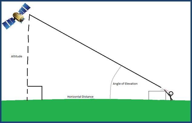 ram (for gathering data on the
International Space Station)
Top
ram (for gathering data on the
International Space Station)
Top
![]()
Data, Calculations, and Results Top
Raw Observation Data for International Space Station
|
Observation |
Angle of Elevation (degrees above horizon) +/- 0.5º |
Longitude +/- .05 |
Latitude +/- .05 |
|
ISS 1/02/11 |
34º |
-122.2 |
50.5 |
|
ISS 1/02/11(later) |
20º |
-131.1 |
51.7 |
|
ISS 1/03/11 |
24º |
-130.6 |
50.8 |
|
ISS 1/10/11 |
29º |
-129.6 |
48.2 |
Raw Observation Data for CZ-4B R/B (from computer)
|
Observation |
Velocity (in km/s) +/- .005 km/s |
Longitude +/- .05 |
Latitude +/- .05 |
|
CZ-4B R/B 1/10/11 |
7.80 km/s |
-121.2 |
48.8 |
|
CZ-4B R/B 1/11/11 |
7.80 km/s |
-111.2 |
47.4 |
|
CZ-4B R/B 1/12/11 |
7.80 km/s |
-124.4 |
45.1 |
|
CZ-4B R/B 1/13/11 |
7.81 km/s |
-114.1 |
42.2 |
|
CZ-4B R/B 1/14/11 |
7.81 km/s |
-128.4 |
|
|
CZ-4B R/B 1/17/11 |
7.82 km/s |
-121.0 |
35.6 |
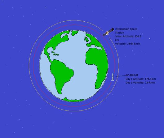
International Space Station Altitude Calculations (ignoring curvature of the Earth)
- ISS Observation 1: tan(34) * 568,861.7m (horizontal distance) = 383.7 km altitude
- ISS Observation 2: tan(20) * 927,524.13m (horizontal distance) = 337.5 km altitude
- ISS Observation 3: tan(24) * 833,161.57m (horizontal distance) = 370.9 km altitude
- ISS Observation 4: tan(29) * 604,341.72m (horizontal distance) = 334.9 km altitude
International Space Station Altitudes
|
Observation |
Altitude (in meters) above Earth's Surface +/- 24 km |
|
ISS 1/02/11 |
383.7 km |
|
ISS 1/02/11 |
337.5 km |
|
ISS 1/03/11 |
370.9 km |
|
ISS 1/10/11 |
334.9 km |
|
|
Mean = 356.8 km |
CZ-4B R/B Altitude Calculations
- Formula: r = (G * M)/ (v^2)
 G = Gravitational Constant
(6.673 x 10^-11 m^3 kg^-1 s^-2)
G = Gravitational Constant
(6.673 x 10^-11 m^3 kg^-1 s^-2)- M = Mass of the Earth (5.9742 x 10^24 kg)
- v = Velocity of the Satellite (in km/s)
- Altitude = r – radius of the Earth (6378100m)
· CZ-4B R/B Observation 1: (6.67E-11 * 5.97E24)/ (7800.^2) = 6552570.118 – 6378100 = 174,470 m = 174.4 km (assuming circular orbit)
· CZ-4B R/B Observation 2: (6.67E-11 * 5.97E24)/ (7800.^2) = 6552570.118 – 6378100 = 174,470 m = 174.4 km (assuming circular orbit)
· CZ-4B R/B Observation 3: (6.67E-11 * 5.97E24)/ (7800.^2) = 6552570.118 – 6378100 = 174,470 m = 174.4 km (assuming circular orbit)
· CZ-4B R/B Observation 4: (6.67E-11 * 5.97E24)/ (7810.^2) = 6535800.912 – 6378100 = 157,701 m = 157.7 km (assuming circular orbit)
· CZ-4B R/B Observation 5: (6.67E-11 * 5.97E24)/ (7810.^2) = 6535800.912 – 6378100 = 157,701 m = 157.7 km (assuming circular orbit)
· CZ-4B R/B Observation 6: (6.67E-11 * 5.97E24)/ (7820.^2) = 6519095.996 – 6378100 = 140,996 m = 140.9 km (assuming circular orbit)
CZ-4 R/B Altitudes
|
Observation |
Altitude (in kilometers) above Earth's Surface +/- .05 km |
Horizontal Surface Distance (in kilometers) +/- .05 km |
|
CZ-4B R/B 1/10/11 |
174.4 km |
|
|
CZ-4B R/B 1/11/11 |
174.4 km |
918.1 km |
|
CZ-4B R/B 1/12/11 |
174.4 km |
128.4 km |
|
CZ-4B R/B 1/13/11 |
157.7 km |
784.3 km |
|
CZ-4B R/B 1/14/11 |
157.7 km |
476.5 km |
|
CZ-4B R/B 1/17/11 |
140.9 km |
1096 km |
International Space Station Velocity Calculations
- Formula = V=

- G = Gravitational Constant
- M = Mass of the Earth (what the satellite is orbiting)
- r = the radius of the orbit the satellite (to the center of mass the satellite is orbiting)
- ISS Observation 1: sqrt((6.673E-11 * 5.9742E24) / (383700 + 6378100) = 7678.374 m/s = 7.678 km/s
- ISS Observation 2: sqrt((6.673E-11 * 5.9742E24) / (337500 + 6378100) = 7704.741 m/s = 7.704 km/s
- ISS Observation 3: sqrt((6.673E-11 * 5.9742E24) / (370900 + 6378100) = 7685.652 m/s = 7.686 km/s
- ISS Observation 4: sqrt((6.673E-11 * 5.9742E24) / (334900 + 6378100) = 7706.233 m/s = 7.706 km/s
5.
![]() International Space Station
Velocities
International Space Station
Velocities
|
Observation |
Velocity (in kilometers per second) +/- .005 |
|
ISS 1/02/11 |
7.678 km/s |
|
ISS 1/02/11 |
7.704 km/s |
|
ISS 1/03/11 |
7.686 km/s |
|
ISS 1/10/11 |
7.706 km/s |
|
|
Mean = 7.694 km/s |
Graph Illustrating the Altitude vs.
Velocity of ISS vs. CZ-RB
 Top
Top
![]() I
I
llustrating Fall in Altitude over time for CZ-4B (rocket body)

Comparison of the both satellites Altitudes and Orbits
![]()
Conclusion Top
The overall purpose of this investigation was to observe satellites and formulate some general theories. More specifically, the International Space Station and a Chinese derelict rocket body were observed, and data was gathered about the respective altitudes and velocities. The altitudes and velocities of each satellite can then be compared to discover if velocity affects altitude. It was thought that the higher the altitude, the lesser the velocity would be due to the fact that the Gravitational field strength of the Earth would not be as strong, and the satellite would not need as high as a velocity to stay in orbit. The second part of the hypothesis was to discover if the altitude of a derelict rocket body fell over time due to the effects of atmospheric gases, solar pressure, and gravity itself. Our hypothesis proved to be correct because of the fact that the Chinese rocket body was at a lower altitude and had a slower velocity than the International Space Station. Also, the altitude of the Chinese rocket body fell drastically over a period of eight days. Furthermore, the process of collecting the data was relatively simple, and the results were simple, clear, and understandable. The altitudes were not hugely varied with each observation; it stayed consistent. The fact that the Chinese rocket body fell in altitude was clearly illustrated and contained no outliers. In addition, the variables measured and maintained each had the characteristic of being simple to understand and manipulate. For example, there were no independent variables formulated due to the fact that nothing was being manipulated; it can be said that the satellites manipulate themselves. Therefore, the manipulation of the independent variables can be thrown out. Also, the dependent variables proved slightly difficult to measure, and yet the data gathered proved sufficient. Measuring the angle, finding the latitude and longitude, and finding the horizontal surface distance all proved to be quick processes. This was illustrated in the collected data. Lastly, the controlled variables did not have to be part of the process because only a catastrophic event would have altered those respective variables. One has to understand, however, that the process of coming to the type of setup and method we had was laden with errors, miscalculations, and mistakes.
![]() When discussing the errors of the
experiment, it is important to understand that most could be avoided with
proper funding and equipment. Several major errors showed themselves during the
experiment and seemed to alter the data slightly. To explain, there was human
error in actually observing the satellites and finding the angle of elevation.
The angle found was based on the line of sight of the observer, and that could
alter the actual angle drastically. The fix to this error would obviously be
more precise observing equipment and steadying of the geometrical compass used
by the observer. Furthermore, probably the largest and most uncontrollable
error would be that of the missing angle in calculating the altitude. The
curvature of the Earth was neglected because it was slight for the distances
involved in this investigation; however, that angle of curvature, as it is
called in this experiment, could alter the data, albeit slightly. The only
probable fix to that error would be to implement observation equipment that
takes that angle into account when finding the angle of elevation. In addition,
both satellites, it was assumed, had elliptical orbits that changed the real
altitudes and velocities calculated. This proved the most difficult error to
deal with, and unfortunately, this error had to be neglected for the sake of
the experiment. The solution to this error would be to calculate the orbit with
eccentricity, recording maximum and minimum altitudes in order to find the
altitude at a certain point. This experiment was indeed full of errors, both
human and uncontrollable, and it is believed that this investigation could be
carried out with greater accuracy. However, the hypothesis proved to be correct,
and the errors would have altered the data only slightly. Therefore, they were
neglected for the sake of this experiment.
When discussing the errors of the
experiment, it is important to understand that most could be avoided with
proper funding and equipment. Several major errors showed themselves during the
experiment and seemed to alter the data slightly. To explain, there was human
error in actually observing the satellites and finding the angle of elevation.
The angle found was based on the line of sight of the observer, and that could
alter the actual angle drastically. The fix to this error would obviously be
more precise observing equipment and steadying of the geometrical compass used
by the observer. Furthermore, probably the largest and most uncontrollable
error would be that of the missing angle in calculating the altitude. The
curvature of the Earth was neglected because it was slight for the distances
involved in this investigation; however, that angle of curvature, as it is
called in this experiment, could alter the data, albeit slightly. The only
probable fix to that error would be to implement observation equipment that
takes that angle into account when finding the angle of elevation. In addition,
both satellites, it was assumed, had elliptical orbits that changed the real
altitudes and velocities calculated. This proved the most difficult error to
deal with, and unfortunately, this error had to be neglected for the sake of
the experiment. The solution to this error would be to calculate the orbit with
eccentricity, recording maximum and minimum altitudes in order to find the
altitude at a certain point. This experiment was indeed full of errors, both
human and uncontrollable, and it is believed that this investigation could be
carried out with greater accuracy. However, the hypothesis proved to be correct,
and the errors would have altered the data only slightly. Therefore, they were
neglected for the sake of this experiment.
![]() In satellite tracking, it is vital to
discover the satellite that best fits the requirements for your experiment. In
this case, the International Space Station proved to be an excellent choice for
observing the altitude and velocity. Several strong points illustrate the
simplicity of observing the Space Station. For example, the station was
brighter than any star in the night sky, and therefore, it was clearly visible.
Second, the Space Station flew over the observing position each night and
morning, so choosing days to observe proved to be a quick process (except for
the fact that it’s cloudy and rainy almost every day in Oregon). In addition,
the observation of the satellite was quick because of the fact that it was
clearly visible. Lastly, the orbit of the International Space Station will not
decay as long as it is useful for scientists, and therefore, a significant
amount of time is available for observation. These positive aspects easily
outweigh the fact that the orbit is slightly elliptical.
In satellite tracking, it is vital to
discover the satellite that best fits the requirements for your experiment. In
this case, the International Space Station proved to be an excellent choice for
observing the altitude and velocity. Several strong points illustrate the
simplicity of observing the Space Station. For example, the station was
brighter than any star in the night sky, and therefore, it was clearly visible.
Second, the Space Station flew over the observing position each night and
morning, so choosing days to observe proved to be a quick process (except for
the fact that it’s cloudy and rainy almost every day in Oregon). In addition,
the observation of the satellite was quick because of the fact that it was
clearly visible. Lastly, the orbit of the International Space Station will not
decay as long as it is useful for scientists, and therefore, a significant
amount of time is available for observation. These positive aspects easily
outweigh the fact that the orbit is slightly elliptical.
In the case of the Chinese rocket body, observation would have been similar to that of the International Space Station, yet several factors forced me to decide otherwise. Even though the rocket was clearly visible and observation was effortless, the need for accuracy in the data pushed me towards gathering the data on the computer over time. With implementing the computer method, I was able to collect very precise and accurate data that allowed for a clearly formulated conclusion. Furthermore, the data gathered about the Chinese rocket body was a surprise because its altitude fell drastically over such a short period of time. There are only two explanations for this phenomenon. One, the orbit could have been nearing its decay during the time of observation, or two, it could have had a vastly elliptical orbit that would allow for such altitude changes despite the relatively short distance apart for the different observations. Overall, the experiment was difficult to research and outline, simple to carry out and collect data, and straightforward for formulating conclusions.
![]() Bibliography
Top
Bibliography
Top
Anissimov, Michael. “How many Satellites are Orbiting the Earth”. WiseGeek. October 22, 2010. <http://www.wisegeek.com/how-many- satellites-are-orbiting-the-earth.htm>
Dickinson, David. “Satellite Spotting: A Quick How-to Guide”. AstroGuyz. January 20, 2010. <http://astroguyz.com/2010/01/20/satellite- spotting-a-quick-how-to-guide/>
Oberright, John E. "Artificial Satellite". National Aeronautics and Space Administration. 2004. NASA
<http://www.nasa.gov/worldbook/artificial_satellites_worldbook.html>
Paglen, Trevor. Blank Spots on the Map: The Dark Geography of the Pentagon's Secret World. New York: New American Library. 2009.
“Real Time Satellite Tracking”. N2YO. <http://www.n2yo.com>
Robson, Heather. “How to Calculate Elevation and Azimuth”. eHow. September 4, 2010. <http://www.ehow.com/how_6938899_calculate- elevation-azimuth.html>
![]() Sturdevant, Rick W. “From satellite
tracking to space situational awareness: the USAF and space surveillance,
1957-2007”. bnet. 2008.
Sturdevant, Rick W. “From satellite
tracking to space situational awareness: the USAF and space surveillance,
1957-2007”. bnet. 2008.
<http://findarticles.com/p/articles/mi_hb3101/is_4_55/ai_n31196860/?tag=content;col1>